Ryan Mountain, W6/CD-016

Activation Date: 20 January 2018
Transport: Hike Distance: 3 miles
Elev. gain: 1,050 feet Time: 1.5 hours
Rig(s): LNR Precision MTR-3B Band(s): 30, 40m CW
Antenna(s): End-fed half-wave (HF)
Cell Service: None (T-Mobile)
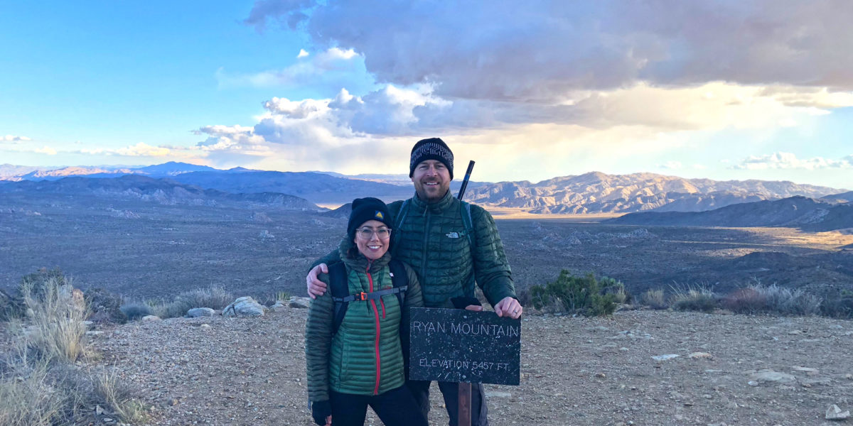
Parking: Ryan Mountain
Trailhead: Ryan Mountain
Fees/Permits: Joshua Tree National Park – $25
Route: Ryan Mountain Trail
Dogs: No  Toilet: Yes

My wife and I were visiting Joshua Tree National Park for our tenth anniversary. Originally, I wasn’t planning on doing SOTA while spending time with my wife but then a friend recommended this hike.  My wife gave her blessing for a short SOTA activation, and so it came to be!  It ended up being a cold and windy, but very beautiful hike.

Continue reading →

Red Lake Peak, W6/NS-062 and Stevens Peak, W6/NS-375

Activation Date: 5 August 2017
Transport: Run/Hike/Climb Distance: 10 miles
Elev. gain: 2750ft Time: 5 hours
Rig(s): FT-817, VX-2R Band(s): 40m, 20m SSB, 2m FM
Antenna(s): End-fed half-wave, 12.5 inch flex whip
Cell Service: Good (T-Mobile)
Parking: Big Meadow Tahoe Rim Trail Trailhead
Trailhead: Round Lake
Fees/Permits: None
Route: Tahoe Rim Trail, Pacific Crest Trail, Off-Trail
Dogs: Yes  Toilet: No

While on a backpacking trip to Round Lake with friends, I wanted to see if I could squeeze in a little bit of summit action.  Originally, I was only going to attempt Stevens Peak, by heading up to a nearby ridge and approaching from the north. Upon doing some more research, I realized I could add a little bit of distance and grab both Red Lake Peak and Stevens Peak in one go.  I looked at several trip reports on PeakBagger.com—most of them consisted of a day hike to both peaks, approaching from the south. So I put together a hybrid of that approach and planned to get an early start on the second day of our backpacking trip, and do it trail-running style.

Continue reading →

W6/NS-170, Black Buttes

Activation Date: 22 July 2017
Transport: Hike/Scramble Distance: 9.5 miles
Elev. gain: 1160ft Time: 4-5 hours
Rig(s): FT-817, VX-2R Band(s): 40m, 20m SSB; 2m FM
Antenna(s): End-fed half-wave, 12.5 inch flex whip
Cell Service: Solid (T-Mobile)
Parking: Grouse Ridge Campground Area
Trailhead: Grouse Ridge Trail
Fees/Permits: None
Route: Grouse Ridge, Glacier Lake trails, cross-country
Dogs: Yes  Toilet: Maybe

Several years before I became a ham, when I first camped at Glacier Lake, this group of peaks called to me. I didn’t get around to climbing any of them that first time, but came back a couple of years later to camp at Glacier Lake, and decided to go for it. We chose the highest peak, since it had the most obvious approach, and it’s a short hike if you happen to already be camping at the lake. It’s a steep hike, followed by a scramble to the summit.

Once I started getting into Summits on the Air, it wasn’t long before I checked to see if this summit qualified. What a great excuse to go backpacking to Glacier Lake again!  Black Buttes became a must-do part of the itinerary for my backpacking trip with a group of friends, though I would end up being the only person in our group to do it.

Continue reading →

W6/CC-072, San Bruno Mountain and KFF-1196, San Bruno Mountain State Park

Activation Date: 15 July 2017
Transport: Hike Distance: 4 miles
Elev. gain: 1,300ft Time: 1.6 hours
Rig(s): FT-817, VX-2R Band(s): 40m SSB
Antenna(s): End-fed half-wave, 12.5 inch flex whip
Cell Service: Solid (T-Mobile)
Parking: Free roadside or ball field
Trailhead: Hillside Blvd, near school
Fees/Permits: None
Route: Fire Road 2, Ridge Trail
Dogs: No  Toilet: No

I’ve had my eye on San Bruno Mountain since long before I was a ham. Having worked at San Francisco International Airport back in 2007-2009, I wondered what it would be like to hike to the top and watch the big planes take off (it’s 5 miles away). I also noted all of the big transmission towers on the top, and figured it was probably closed to public access. It took Summits on the Air to give me enough reason to actually go do it.

Continue reading →

W6/NC-174, Wasno Ridge and KFF-1161, Henry Coe State Park

Activation Date: 8 July 2017
Transport: Hike/Run Distance: 7 miles
Elev. gain: 2000ft Time: 2 hours
Rig(s): FT-817, VX-2R Band(s): 40m, 20m SSB
Antenna(s): End-fed half-wave, 12.5 inch flex whip
Cell Service: Barely (T-Mobile)
Parking: Free roadside
Trailhead: End of Gilroy Hot Springs Road
Fees/Permits: None
Route: Grizzly Gulch, Rock Tower trails going up; Jackson, Anza trails going down
Dogs: No  Toilet: Yes

This is my first full combined SOTA/POTA activation. Wasno Ridge sits inside Henry Coe State Park, WWFF/POTA designator KFF-1161.

This trip was meant to be a loop, inspired by AA6XA’s trip report for Wasno Ridge and Willson Peak. This would be one of my trail-running trips.  However, I forgot one of my water bottles and decided it would be safest to just do Wasno Ridge.  The temperature was forecast to rise sharply and I didn’t want to mess with potentially life-threatening heat issues.  My planned route would take me up the shorter, steeper way to Wasno Ridge.

Continue reading →

W6/SC-155, Mount Bielawski

Activation Date: 4 July 2017
Transport: Hike Distance: <1 mile
Elev. gain: 175ft Time: <30 minutes
Rig(s): FT-817, VX-2R Band(s): 40m, 20m SSB
Antenna(s): End-fed half-wave, MFJ Long-ranger
Cell Service: Marginal (T-Mobile)
Parking: Free roadside, $8 in parking lot
Trailhead: Castle Rock State Park Main Entrance
Fees/Permits: None
Route: Castle Rock Trail
Dogs: No  Toilet: Yes

Mount Bielawski, also known as Mount McPherson, is located on private property. It’s probably possible to get permission to go to the summit proper, but for me it’s a good excuse to visit Castle Rock State Park—a beautiful park on the west side of the Santa Cruz mountains, and a very popular spot for rock climbers.

I had looked at various ways I might activate this summit—including the possibility of just hanging out on the road right below it. In the end, I decided it would be most enjoyable to hike up the Castle Rock Trail—a short trail that starts at the entrance to the state park and loops around right by the park’s namesake peak, Castle Rock.  Having looked at the contour map(s) for this area repeatedly, I decided that most of the ridge along the southeast little corner of the park was within the activation zone.  I wasn’t going to be completely certain until I saw for myself. Continue reading →

W6/SN-039, Leviathan Peak

Activation Date: 4 June 2017
Transport: Hike Distance: .5 miles
Elev. gain: 100ft Time: 15 minutes
Rig(s): FT-817, VX-2R Band(s): 40m, 20m SSB; 2m FM
Antenna(s): SOTABeams linked dipole, 12.5 inch flex whip
Cell Service: None (T-Mobile)
Parking: Side of dirt road, near gate
Trailhead: N/A
Fees/Permits: None
Route: Leviathan Lookout Road
Dogs: Unsure  Toilet: No

This was the second of the two “drive-up” summits I had planned for my trip back from the White Mountains. How could I resist the chance to drive through Monitor Pass—perhaps one of the most scenic mountain passes in the United States?  How could I resist activating a summit with a name like Leviathan Peak? The weather sure didn’t plan on stopping me!  What a beautiful day.

Continue reading →

W6/WH-008, 10940

Activation Date: 2 June 2017
Transport: Hike Distance: <100 yards
Elev. gain: 100ft Time: 15 minutes
Rig(s): FT-817 Band(s): 40m, 20m SSB
Antenna(s): SOTABeams Linked Dipole
Cell Service: Marginal (T-Mobile)
Parking: Free – roadside
Trailhead: White Mountain Road
Fees/Permits: None
Route: Cross country
Dogs: Yes  Toilet: No

Out of the several peaks I planned to activate in the White Mountains, this unnamed peak “10940” was the easiest to get to, and one I had planned on doing last.  That planned changed, as plans often do in the mountains.  First of all, I brought my VW Passat wagon, rather than my AWD Honda Pilot. So once White Mountain Road went from paved to unpaved, things got slow—really slow. The road doesn’t seem to get much maintenance, and it’s probably a difficult road to maintain with the harsh weather conditions and remoteness of it. So it took me almost 40 minutes to cover the 5 miles of unpaved road. A high-clearance vehicle (even not 4×4) would have a much easier time. Either way, make sure your spare tire is ready!

Continue reading →