Ultra-lyte Summits on the Air by Fred KT5X

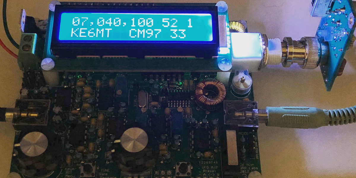
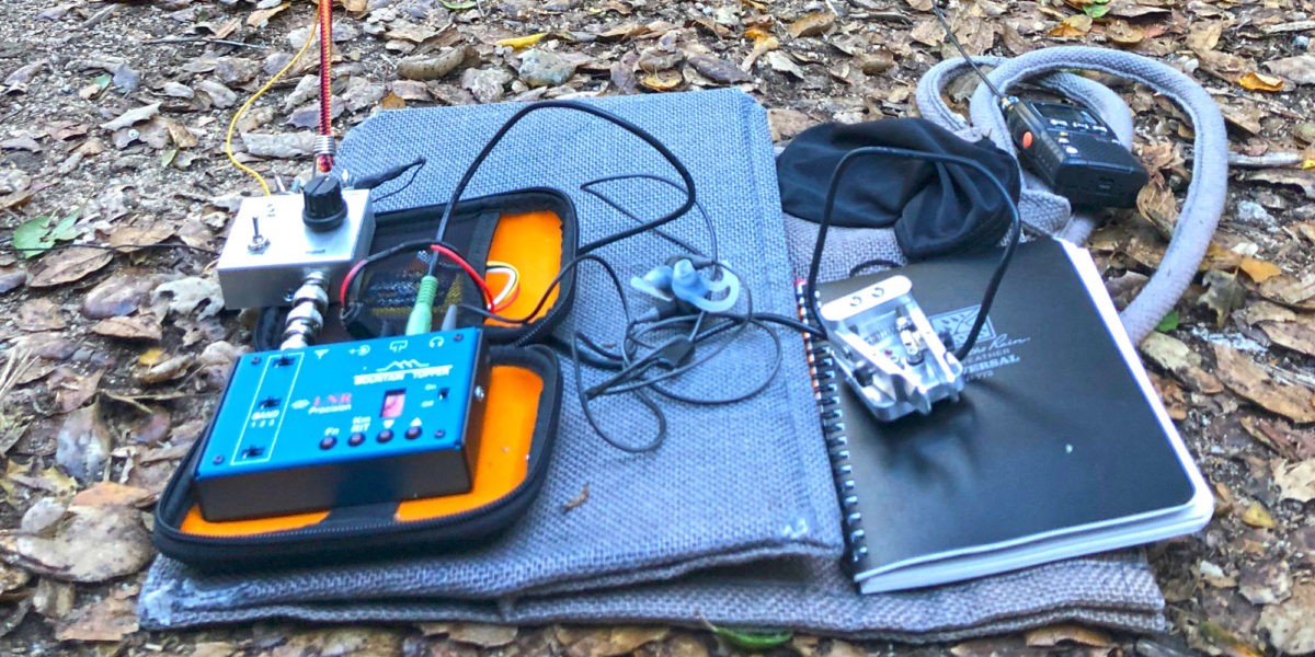
There are a lot of different types of SOTA operators out there. Some like to bring a lot of equipment, some like to bring very little.  For most, it depends on the type of activation they’re doing, or perhaps what equipment they have.  Personally, I like to do a little bit of everything, including lightweight minimal equipment.

I’ve conversed with Fred Maas, KT5X, a number of times on some of the incredible things he’s doing to minimize his SOTA setup.  He has a great trapped end-fed half-wave (EFHW) setup he’s come up with for an antenna.  It uses two small traps to get multi-band function out of a single wire.  Traps certainly aren’t a new thing in the ham world, but tiny traps like his are certainly an original concept.  After getting info on how to build my own, I collaborated with him to design tiny PCBs for the traps.  After feedback from him and a couple of revisions, we had a functional WS0TA trap PCB.  And this thing is tiny!

Continue reading →

Mount Scott – W7O/CS-003

Activation Date: 24 July 2018
Transport: Hike Distance: 4.5 miles
Elev. gain: 1,205 feet Time: 2 hours
Rig(s): MTR-3B Band(s): 40m/20m (cw)
Antenna(s): Linked EFHW 40/30/20m
Cell Service: Marginal (T-Mobile)
Parking: Mount Scott Trailhead
Trailhead: Mount Scott
Fees/Permits: Crater Lake National Park – $25/car for 7 days in the park
Route: Mount Scott Trail
Dogs: No Toilet: No
Antenna Support: Short trees RF Noise: Low

I’ve wanted to visit Crater Lake National Park for a long time. Having planned my visit to Washington state as a road trip, I planned a two-night stay in the park on the way back.  The original plan was for me and my two sons to camp (my wife had to be at work), but we ended up adding my brother-in-law and one of my nephews to the mix, too!  Despite nearby wildfires creating a lot of smoke in the area, we went ahead and did this summit hike up the volcano known as Mount Scott — the highest point in Crater Lake National Park.

Continue reading →

Green Mountain – W7W/RS-074

Activation Date: 22 July 2018
Transport: Drive-Up / Short Hike Distance: 0.5 miles
Elev. gain: 120 feet Time: 12 minutes
Rig(s): MTR-3B, FT-817 Band(s): 40m/20m (cw/ssb)
Antenna(s): Linked EFHW 40/30/20m
Cell Service: Moderate (T-Mobile)
Parking: Summit Lot, via Green Mountain Summer Road
Trailhead: Vista Trail
Fees/Permits: Discover Pass ($11.50 daily, $35 annual)
Route: Walk up the Vista Trail
Dogs: Yes Toilet: Yes
Antenna Support: Lots of trees, fence RF Noise: Low

I was up in my home state of Washington (not DC) for a family wedding and wanted to squeeze in a little bit of SOTA fun.  This summit fit the bill, and also looked like it’d be really enjoyable, with a good view.  Too bad I injured my knee just a few days before the trip!  But not to worry: it turns out this summit has a drive-up option if you don’t mind a few miles of dirt road.

Continue reading →

W6/NC-353, Burdell Mountain – 2018

Activation Date: 17 June 2018
Transport: Hike Distance: 4.8 miles
Elev. gain: 1225 feet Hiking Time: 2.5 hours
Rig(s): FT-817, VX-2R Band(s): 20m, 40m (cw + ssb), 2m fm
Antenna(s): End-Fed Half-Wave with QRPGuys Tuner
Cell Service: Moderate (T-Mobile)
ParkingSan Andreas Drive
Trailhead: San Andreas Drive
Fees/Permits: None
RouteMiddle Burdell, Cobblestone fire roads
Dogs: Yes – off-leash on fire roads Toilet: No
Antenna Support: Some trees RF Noise: Low

I did this summit late last year as my first morse code activation. Last time it was a combo POTA/SOTA activation. This time would be only SOTA.  And it was a heck of a lot warmer too!

Continue reading →

HF Ham Radio on a Budget: QRP Labs, QRPGuys, CW Academy

When I started my amateur radio life as KK6VSI in August of 2015, I wish I could have had the information I’m about to lay out here.  Of course, most of the equipment didn’t yet exist.  So another way of looking at it is that my entry into amateur radio was perfectly timed for a modern Golden Age of Ham Radio.  Part of this Golden Age means you can get a QRP Labs QCX or BITX40, and a QRPGuys Antenna, plus a few other components, and you’re on the air!  Stick with me here, and we’ll get to the details.

Continue reading →

CW Academy Level 2: Listen, listen, listen!

I haven’t written a post in a while, so I figured I’d write a quick update on my progress with learning Morse code for CW operation. I’d completed CW Academy Level 1 at the end of October 2017 and I’ve been doing CW SOTA activations since. CW Academy Level 1 got me from sort of knowing the characters to actually being able to use Morse code to communicate.  I still wasn’t comfortable actually having a conversation, but simple contacts were actually possible and, dare I say it, enjoyable! I had initially gone ahead and signed up for the very next Level 2 class (running Jan-Feb 2018), but soon decided I wasn’t quite ready for it.  I requested to bumped to the next one (running Apr-May 2018).

Continue reading →

Mount Isabel, W6/NC-035

Activation Date: 31 December 2017
Transport: Hike Distance: 7.8 miles
Elev. gain: 2350 feet Time: 3-3.5 hours
Rig(s): LNR Precision MTR-3B, Radioddity GD-77 Band(s): 20, 40m CW, 2m FM
Antenna(s): End-fed half-wave (HF), 12-inch whip (VHF/UHF)
Cell Service: Marginal/None (T-Mobile)
Parking: Side of the road, near CalFire Smith Creek Fire Station
Trailhead: Joseph D. Grant County Park entrance, to left, behind Fire Station
Fees/Permits: None
Route: Along creek, then old ranch roads
Dogs: Yes (on leash)  Toilet: No

I wanted to get in one final SOTA activation for the year, and planned on doing it the week between Christmas and New Year’s eve, but had come down with a nasty cold. Even though I still had a cold, I decided I’d do it on the very last day of the year.  Having seen that Jeff, AA6XA discovered this hike could be done on public land, I couldn’t resist the opportunity to get this one done.  It’s an exceedingly beautiful hike into an isolated part of the Diablo range.

Continue reading →

Copernicus Peak, W6/NC-029

Activation Date: 9 December 2017
Transport: Drive-Up, Short Walk Distance: .4 miles
Elev. gain: 180 feet Time: 15 minutes
Rig(s): LNR Precision MTR-3B, Yaesu VX-2R Band(s): 30, 20, 40m CW, 2m FM
Antenna(s): End-fed half-wave, 12-inch whip
Cell Service: Marginal (T-Mobile)
Parking: Side of the road, CA-130
Trailhead: N/A
Fees/Permits: Permission needed
Route: Up road, trail past lookout
Dogs: No  Toilet: Yes, near observatory

I’d been wanting to do this activation before the end of the year, but kept putting it off because it’s easy, but also kind of a long drive for something that looks so close. It’s easily visible from my house on most days, being the only summit around with several big telescopes.  But it’s an hour or more to drive there.  This one had several firsts for me! First European DX—Spain. First aeronautical mobile contact. First time getting more than 50 QSOs in a single activation. My timing turned out to be quite good!

Continue reading →

Ben Lomond Mountain, W6/NC-178

Activation Date: 29 November 2017
Transport: Drive-Up Distance: N/A
Elev. gain: N/A Time: 5 minutes
Rig(s): LNR Precision MTR-3B Band(s): 30m CW
Antenna(s): End-fed half-wave
Cell Service: None
Parking: Side of Empire Grade
Trailhead: N/A
Fees/Permits: None
Route: N/A
Dogs: N/A  Toilet: No

I was over in Santa Cruz for work, so decided to make a “quick” detour on the way back over the hill so I could activate this summit. I’ve had my eye on it for a while, so I posted an alert on SOTAWatch and squeezed in some time to do it. The detour isn’t actually very “quick,” but it’s within reason.

Continue reading →

Santa Rita Peak, W6/CC-022

Activation Date: 18 November 2017 (local time)
Transport: Drive-Up, short hike Distance: 1 mile
Elev. gain: 250ft Time: 20 minutes
Rig(s): LNR Precision MTR-3B, Yaesu VX-2R Band(s): 20m CW, 2m/70cm FM
Antenna(s): End-fed half-wave, 12-inch whip
Cell Service: None (T-Mobile)
ParkingSide of road R11
Trailhead: Side of road R11
Fees/Permits: Multiple permits—see post on Peak 4850
Route: Dirt road to summit col, small trail to activation zone
Dogs: Yes  Toilet: No

This (almost) drive-up summit was one of the most difficult “easy” summits I’ve activated. After having completed the intense bushwhacking on Peak 4850, I was looking forward to an easy summit. This one would turn out to be deceptively hard, thanks to a crazy guy on a dirt bike.

Continue reading →