American Morse Equipment “DCP” Paddle

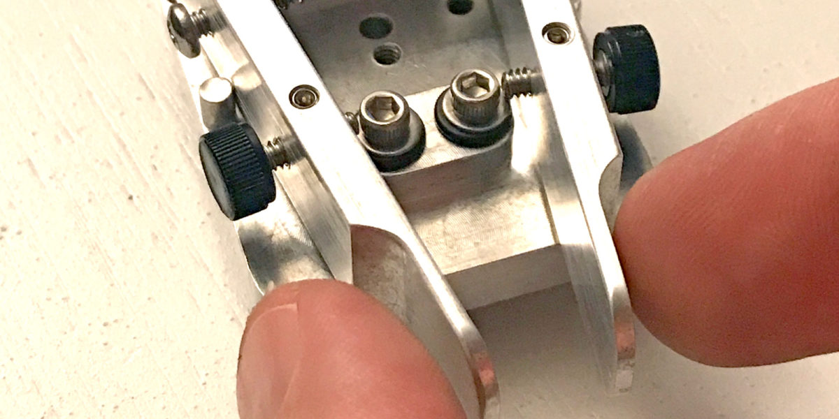
OK, so saying “DCP Paddle” is redundant.  “DCP” stands for “Dirt Cheap Paddle.” While this paddle is inexpensive compared to a lot of morse/CW paddles out there, I would definitely not call it “cheap.”  It is exquisitely designed and expertly machined by Doug W6AME of American Morse Equipment.  I don’t remember where I first heard about his paddles and keys, but I knew I had to have one as soon as I saw it.  The DCP is the least expensive paddle he makes (hence the name) but doesn’t lack quality.  I have a pretty tight budget for my ham activities and equipment, so I was holding off on getting one until I really needed it.

Continue reading →

Oak Hill, W1/HA-179

Activation Date: 14 August 2017
Transport: Car Distance: 25 yards
Elev. gain: N/A Time: 5 minutes
Rig(s): FT-817, VX-2R Band(s): 40m, 20m SSB
Antenna(s): End-fed half-wave, 12.5 inch flex whip
Cell Service: Excellent (T-Mobile)
Parking: At the top of the hill
Trailhead: N/A
Fees/Permits: None
Route: N/A
Dogs: Yes  Toilet: No

For my family reunion, most of my siblings and I stayed at a chalet in Madison, New Hampshire. Very near where we were staying was this drive-up SOTA summit. I actually ended up visiting several times, and doing SOTA operations twice. The view is absolutely amazing.  The day I activated this summit, I tried twice. The first one, at sunrise, was completely unsuccessful with zero contacts made.  The second one, at sunset, was successful, but zero points with only three contacts made.

Continue reading →

Mount Washington, W1/HA-001 and KFF-2667

Activation Date: 11 August 2017
Transport: Hike Distance: 9.5 miles
Elev. gain: 4000ft Time: 6-7 hours
Rig(s): FT-817, VX-2R Band(s): 40m, 20m SSB
Antenna(s): End-fed half-wave, 12.5 inch flex whip
Cell Service: Marginal (T-Mobile)
Parking: Ammonoosuc Ravine Trailhead
Trailhead: Ammonoosuc Ravine
Fees/Permits: $5 Day Use (cash)
Route: Ammonoosuc Ravine Trail, Crawford Path, Gulfside Trail, Jewell Trail
Dogs: Yes  Toilet: Yes

Ever since hearing about Mount Washington as a kid, I’ve wanted to go to the top. My father would tell stories of driving to the top, and having the brakes smoking on the way down. Decades later, as an avid hiker and SOTA enthusiast living on the west coast of the United States, it still called to me, but it was over 2600 miles (4184km) away. So when plans for a New England family reunion started coming together for this August, I knew the chance had come.

Continue reading →

Red Lake Peak, W6/NS-062 and Stevens Peak, W6/NS-375

Activation Date: 5 August 2017
Transport: Run/Hike/Climb Distance: 10 miles
Elev. gain: 2750ft Time: 5 hours
Rig(s): FT-817, VX-2R Band(s): 40m, 20m SSB, 2m FM
Antenna(s): End-fed half-wave, 12.5 inch flex whip
Cell Service: Good (T-Mobile)
Parking: Big Meadow Tahoe Rim Trail Trailhead
Trailhead: Round Lake
Fees/Permits: None
Route: Tahoe Rim Trail, Pacific Crest Trail, Off-Trail
Dogs: Yes  Toilet: No

While on a backpacking trip to Round Lake with friends, I wanted to see if I could squeeze in a little bit of summit action.  Originally, I was only going to attempt Stevens Peak, by heading up to a nearby ridge and approaching from the north. Upon doing some more research, I realized I could add a little bit of distance and grab both Red Lake Peak and Stevens Peak in one go.  I looked at several trip reports on PeakBagger.com—most of them consisted of a day hike to both peaks, approaching from the south. So I put together a hybrid of that approach and planned to get an early start on the second day of our backpacking trip, and do it trail-running style.

Continue reading →