| Activation Date: 4 June 2017 | |
| Transport: Hike | Distance: .5 miles |
| Elev. gain: 100ft | Time: 15 minutes |
| Rig(s): FT-817, VX-2R | Band(s): 40m, 20m SSB; 2m FM |
| Antenna(s): SOTABeams linked dipole, 12.5 inch flex whip | |
| Cell Service: None (T-Mobile) | |
| Parking: Side of dirt road, near gate | |
| Trailhead: N/A | |
| Fees/Permits: None | |
| Route: Leviathan Lookout Road | |
| Dogs: Unsure | Toilet: No |
This was the second of the two “drive-up” summits I had planned for my trip back from the White Mountains. How could I resist the chance to drive through Monitor Pass—perhaps one of the most scenic mountain passes in the United States? How could I resist activating a summit with a name like Leviathan Peak? The weather sure didn’t plan on stopping me! What a beautiful day.
Getting there
I was coming back from the White Mountains—a desert mountain range immediately to the east of the Sierras. Highway 89 rises sharply out of the Topaz Lake area, quickly gaining elevation for some of the most expansive and colorful views you’ll get anywhere. This highway is closed in the winter, though I’m not sure where they close it, as I was there in summer. I think it had recently been opened, since some sources still reported it as closed.
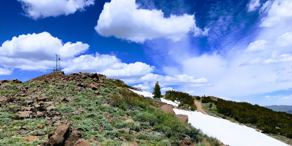
About 9.5 miles from the junction of Highways 89 and 395, you’ll find Leviathan Lookout Road. As far as I could tell, it’s not signed—so I almost missed it. It just intersects Highway 89 directly, at a right angle. So don’t go too fast or you’ll miss it! Getting on the dirt road, it’s about 1-1.5 miles to the gate. When I was there, the gate was open, but it had a bunch of locks dangling from it, so I assume it’s usually locked. I parked at the gate anyway, and scoped out the road ahead on foot. Winds were a steady 15-20mph at that spot, with gusts around 40mph. Going around the bend to the summit, I found a big snowbank blocking the road. Nature had put its own barrier there!

Looking up the road to the summit
I went back to my car to have a snack and enjoy the sounds of the car being buffeted by the wind, before embarking on my little mini-hike to the top.
The climb
To avoid having to walk on slippery snow, and to take a more direct approach, I decided to just go straight up the spine of the summit from the car. I left the road and walked straight up the ridge. From there, I could see the snowbank below.

The snowbank covers quite a bit of road
Seeing open road past the snowbank, I worked my way back down to the road and followed that to the summit. There was another snowbank in the summit area, just past the solar panels, which I just walked straight across. On this side of the summit ridge, there wasn’t a whole lot of wind. The bulk of the wind seemed to be coming from the southwest.

Summit in sight
Once I got up onto the summit ridge, there was a considerable amount of wind—enough to make it slightly difficult to stand up straight. I explored a bit, including a little walk around the lookout platform (video in the Google Photos album). While looking around, I checked for cell service—nothing. That would have the potential to make things difficult.
Operation
Finishing my brief exploration of the top, I went back down to the area with the solar panels. I ended up actually setting up my dipole on the snowfield just above the solar panels. There was a nice hole in the snow (probably a rock sticking up, with melt around it), in which I stuck my squid pole to support the center of the dipole. I pulled out my APRS setup, which consisted of a dual-band HT, Mobilinkd TNC, and Android phone. I got that running in beacon mode while finishing setup of everything.
Starting out on 20m, I called CQ a few times, getting nothing back. So I sent out a self-spot on APRS (after determining my beacon had gone somewhere). The self-spot message didn’t get through. Then, I tried a few local repeaters (including the one right next to me) to see if I could raise anyone. No-go. So I resigned to calling CQ until I (hopefully) got someone. After a few minutes I actually did manage to get Jim K6LR, not far away from me in Nevada. He had either heard me calling, or saw me on the scope and tuned in—I can’t remember which. We exchanged information and chatted a bit. I asked if he could spot me and he agreed to. So I kept calling CQ on that frequency for a while, getting no responses. About 15 minutes later, Jim K6LR came back on to let me know he was about to spot me. I thought he already had! Anyway, I let him know I was going to switch over to 40m and gave him the frequency. He was able to hear me over there, too, since we had line of sight comms.
After getting on 40 meters, apparently the spot had finally made it out. I quickly got 4 more contacts, including an S2S (summit-to-summit) with N6JFD over on W7N/TR-007, Genoa Peak. Yay! I always love getting S2S in the log. My 2m HT started making noise occasionally, too, but I couldn’t make out anything.
As much as I enjoyed chillin’ on the snow with my radios, I wanted to get home to my family after being gone for a few days. Time to pack it up and head out!
On my way down, I snagged an excellent panorama of the mountains and valley to the southeast.

Looking south/southeast from near the summit
The wind had died down a little bit when I came back around the bend to my car. Phew! Overall, a pleasant activation, even if it did take a bit longer due to no self-spotting. Thanks to all the chasers, and especially to Jim for spotting me!
Activation log
| Time | Call | Band | Mode |
| 20:53z | K6LR | 14MHz | SSB |
| 21:26z | W7RV | 7MHz | SSB |
| 21:35z | N6JFD | 7MHz | SSB |
| 21:38z | K7VOC | 7MHz | SSB |
| 21:45z | K6HPX | 7MHz | SSB |