| Activation Date: 14 October 2017 | |
| Transport: Hike | Distance: 22 miles |
| Elev. gain: 6200ft | Time: 12-16 hours |
| Rig(s): Yaesu FT-817 | Band(s): 40m, 20m SSB |
| Antenna(s): End-fed half-wave | |
| Cell Service: Marginal to moderate (T-Mobile) | |
| Parking: Whitney Portal | |
| Trailhead: Whitney Portal | |
| Fees/Permits: $15 – lottery/quota system | |
| Route: Mount Whitney Trail | |
| Dogs: No | Toilet: Yes |
Mount Whitney is the highest summit in the contiguous United States and the Sierra Nevada, with an elevation of 14,505 feet (4,421 m). Last year, I summited it by doing it as a trail-run, getting the round trip done in 9 hours. This time, I wanted to experience it as a more traditional hike, with an overnight stay with friends along the trail before going up the summit. With the exception of losing my antenna to the mountain, it was practically a perfect trip.
Getting there
Many other people have written about Mount Whitney and how to get permits, where to stay, and all other possible details you’d need to make a trip happen. So I won’t go into detail about that. Here and here are a couple of good links to get you started.
Way back in February, I submitted a lottery application for several different dates and combinations. I asked several of my friends if they’d like to join me. I got some interest from a couple of them and put in for four spots. The lottery accepts applications from Feb 1st through March 15th. Around April 1st, they let you know if you’ve received any of your dates. I had applied for dates all throughout summer and into fall and ended up getting permits for a two-night stay October 13th through 15th.
Come time to go, we’d gotten down to three people, and plans were set. It would be myself and my friend Christian, and his friend Larry. Christian and I drove down to Lone Pine from San Jose, while Larry would be driving from Reno to meet up with us.
Christian and I arrived in Lone Pine around 1300, going straight to the Eastern Sierra Interagency Visitor Center (that’s a mouthful!). We picked up our permits, got the briefing about the rules (pack out your poo!), and Christian rented a bear canister (required – I already owned one).

View of Mount Whitney from the Visitor Center
We went and had lunch at The Grill—pretty good eats! Then we headed up to the trailhead (AKA Whitney Portal). The road that takes you there is aptly named “Whitney Portal Road.” You simply follow it all the way to the end and park, first-come, first-served.
Larry would be arriving a couple hours later, so Christian offered to hang out at the Portal and wait for Larry, while I went ahead and started the hike. We’d be staying overnight at Outpost Camp one or both nights, which is about 3.8 miles up the Mount Whitney Trail at about 10,360ft elevation.
Hike to Outpost Camp
With my backpack already packed and ready to go, I put it on and walked over to the trail entrance. Christian got an excellent shot of me at the entrance, ready to embark.
Ready to roll!
The hike started out a little bit tough. Going from sea level to 8300 feet elevation in one day and throwing a 45lb pack on isn’t the easiest thing to do! But after 10 minutes or so, I started to settle into a maintainable pace. On the lower parts of the trail, there were some really nice fall colors.
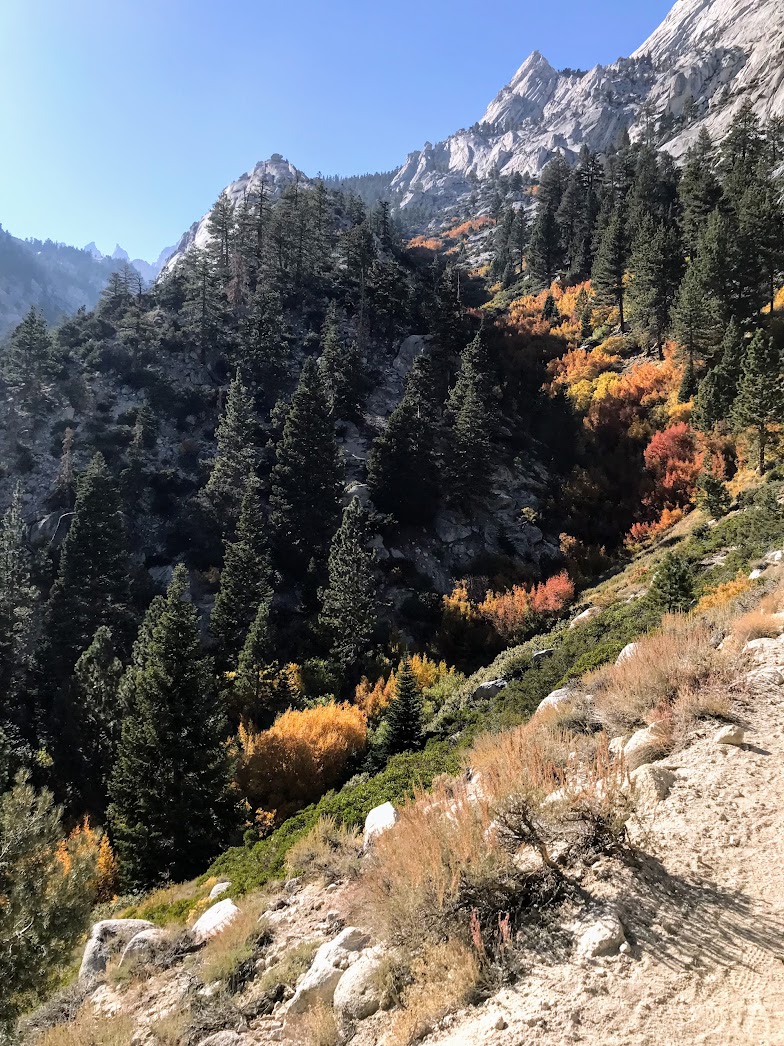
Autumn colors on the Mount Whitney Trail
The Mount Whitney Trail is practically a super-highway of a trail. It is very easy to follow and has very few junctions. The junctions all seemed to have signage pointing one in the direction of the main trail. There are stream crossings here and there, usually with conveniently-placed rocks. I know a lot of volunteers put time into building and maintaining this trail, and I thank them. One of the stream crossings is particularly long, so it’s got a series of logs placed across it for crossing.

Crossing Lone Pine Creek
As you climb, the greenery gets thinner and thinner. Eventually, you can tell you’re getting near treeline. Views of the upper mountains really start to open up.

Nearing the “Whitney Zone”
Just past the above photo, there’s a sign letting you know you’re entering the Whitney Zone, and that the appropriate permits are required. Interestingly, both on last year’s trip and this one, I never had anyone check my permit. Of course, I wouldn’t travel without it, but I just find it worth nothing, I never saw a single ranger on the whole trip.
Getting close to Outpost Camp, the trail descends slightly, into a sort of marshy field. It’s a very beautiful spot.

Marshy area of Lone Pine Creek
Arriving at Outpost Camp, you can’t miss it. It’s a pretty flat area, with lots of obviously great spots to set up tents. I quickly located an area large enough for two tents and proceeded to get set up.

Outpost Camp
Once I got everything set up, I went and chatted with neighboring campers a bit. Then I went and collected water for dinner and part of the next day’s hike. Lone Pine Creek was icy in places, and I actually ended up getting a bit of frost-nip on a couple of my fingers, from dipping my filter container into the creek. Having collected the water I needed, I ate a sandwich and some ramen. I don’t think ramen has ever tasted so good!
A couple of hours later, waiting in the dark down the trail from Outpost Camp, I saw two headlamps approaching. I was Christian and Larry! I helped where I could with the setup of their stuff, but I honestly wasn’t much help. They ate dinner while we all chatted about the next day, then we went to bed. We’d be getting up at 04:00, hitting the trail by 05:00 the next morning.
Summit day
I didn’t sleep very well. I rarely do at high elevation. In this case, in addition to the thin air, it was also quite cold—less than 25°F. My old sleeping bag is rated for 20°F or so, but as is the case with almost all sleeping bags, the rating doesn’t mean you’ll be comfortable at that temperature. Even with my two sleeping pads, I still had a bit of a chill all night. Nonetheless, I did get some sleep.
I had scooped some more water into my cooking pot the night before, so I wouldn’t have to go back to the stream in the morning. As expected, it had mostly frozen. A fun little experiment, but didn’t add too much time to making my morning coffee.

Let’s turn this ice into coffee!
Getting the whole group ready took a bit longer than planned, so we ended up starting our hike around 05:40. Not too big of a deal, since our main time constraint was that we wanted to get back to camp at a reasonable time. During other times of the year, thunderstorms and other weather phenomena can be an issue, so it’s usually good to be off the summit around 12:00-13:00. We would have no such issue, with calm winds and no storms on the forecast. In fact, we probably couldn’t have asked for better weather.
We started out the hike all bundled up, and it wasn’t long before we were generating enough heat to shed a couple of layers. About 20 minutes into the hike, the first hints of a sunrise started to appear.

First light of the day
One of my favorite mountain phenomena is alpenglow. We were treated to an excellent view of this on Mount Whitney, 4000 feet above us.

Alpenglow on Mount Whitney
Above treeline, the granite terrain gets a lot more rugged, and the trail has many rock-step sections. A little way past Trail Camp and the sun was in full effect on the mountain ridge above us.

Sunny mountain ridge (Whitney far right, I think)
There’s a section of the trail called the “99 Switchbacks.” There really are 99 of them, by our count. The scenery continued to be beautiful as we zig-zagged back and forth up the face of this massive ridge. The combination of early morning light, and high elevation, always makes for amazingly dramatic contrasts. The sun shone on the light-colored granite and spots of snow with almost blinding intensity, while the sky to the west simmered a deep midnight blue.

Continuing to climb the ridge
The trail, for the most part, was clear of any ice and snow, with few exceptions. One of those was the section with cables. During some times of the year, this section can be completely covered in snow and ice. In our case, we simply had to skirt to the right of it.

That ice has been there a while!
There’s a part of the trail called “Trail Crest.” It’s at about 13,500 feet. This is the point where the trail goes up over the ridge of peaks that lead to Mount Whitney. On one of the last switchbacks before reaching Trail Crest, you can just barely make out the summit hut on top of Mount Whitney.

One of the last few switchbacks. If you look very carefully, you can see Mount Whitney off to the right
Many of the peaks leading up to Mount Whitney look higher than Mount Whitney itself since they’re closer. In fact, Christian kept asking me where Whitney was since there were so many higher-looking peaks.

Looking toward Mount Whitney (highlighted)
Arriving at Trail Crest, there’s a nice little break spot. It’s pretty common to see people hanging out here, enjoying the views. You can see both sides of the ridge from here, over to Mount Hitchcock and the Hitchcock Lakes to the west, as well as Trail Camp and Wotan’s Throne to the east.

Trail Crest
After a short downhill section, you’ll come across the junction where the Mount Whitney Trail meets up with the last 1.9 miles of the John Muir Trail (JMT). One of these days I’ll get around to doing that.

JMT Junction
From here, the trail begins climbing again, and the terrain gets rougher. There are lots of big rocks to step over, climb onto, and step between. For me, around 13.5k feet is right around where I really start feeling the effects of the elevation. So every bit of climbing feels like a lot more work than down lower. I also find I need to keep the water, electrolytes, and ibuprofen coming, to stave off a headache and other symptoms. Having done this high-elevation stuff many times now, this is routine and nothing for me to be concerned about. My fellow hikers, Christian and Larry, seemed to be doing well too.
This side of the ridge, to me, has the most breathtaking scenery. It’s so expansive and dramatic looking.

Looking back toward the JMT junction
The trail travels along the back side of the ridge, passing several of the “needles” leading to the Mount Whitney summit, which is in view most of the time (though pretty distant-looking!).

Working our way toward the summit
After passing all of the smaller peaks, the trail swings around to the west, before taking a turn to the east for the final ascent. It occurred to me later, that you could probably take a (steep) shortcut to the summit by bypassing this final sweeping switchback.

Heading west before final climb up back of Mount Whitney
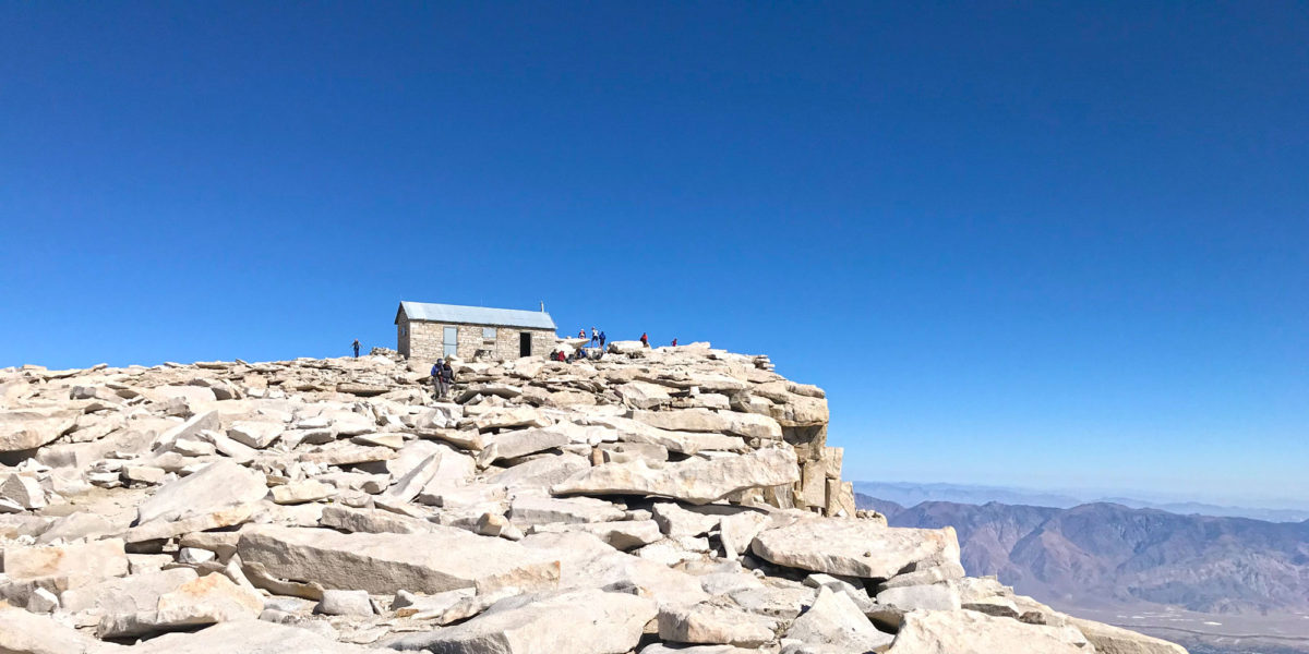
Before you know it, the summit hut comes into view, with the true summit just beyond.

Approaching the summit of Mount Whitney!
Arriving at the summit, I put my name and date in the log, along with the note: “Summits on the Air – KE6MT!”

This summit log gets a lot of use!
After hanging out a few minutes, having a snack and some water, I got to work setting up the radio equipment. Knowing the layout of the summit having visited last year, I had an idea of what I wanted to do. I wanted to throw my end-fed antenna over a nice vertical cliff, and keep it off the cliff face with my squid pole. I also wanted to make sure I wasn’t in the way of anyone, or their views. So I would find a spot just off the summit proper.
Operation
I ended up settling on a spot just north of the summit proper, maybe 10 vertical feet from the summit (it’s a pretty flat summit). This was a nice vertical northeast-facing cliff, with a ledge about 50 feet below. I unwound the whole antenna wire, and some of the paracord at the end. I secured what was left of the paracord to make sure it would stay on the winder. I took the winder and some of the wire and gave it a good throw off the cliff, hoping it would make it past the ledge below. It didn’t make it past the ledge, but I still had enough wire hanging to make the whole setup pretty vertical (which is what I was going for). I got Christian to come hold the wire for me while I propped up my squid pole in the rocks. I think I was making him a little bit nervous, trying to manipulate the wire and pole right near the edge of the cliff. The winder had actually become lodged between two rocks on the ledge below, and I was trying to free it. I gave up on that, figuring I’d solve it later during tear-down. I put the pole in place. It had a bit of wire wrapped around it, so it wasn’t perfectly the way I imagined it, but it would work well! During all of this, a helicopter was flying around below us. At the time, I thought it was a tour flight of some kind.

Wire horizontal for about 15 feet, then drops straight down the cliff face
I hooked the wire up to my antenna matcher and got it tuned up on 40 meters. I found the cell service to be really “on or off” depending on where and how I stood on the summit. This made a lot of sense since the nearest tower is probably over a dozen miles away. Getting a good cell signal, I found a clear frequency and spotted myself. I started calling CQ and the answers started coming in right away.

Operating position (towel to keep sun off radio)
After getting a number of contacts all over the West Coast on 40 meters, I switched over to 20 meters and got several more there, all over the US. Some I had to pull out of the noise, but this is quite easy on an almost windless day in the middle of nowhere!

Christian managed to get a shot of me operating
For whatever reason, I totally forgot to pull out my handheld and see if anyone would answer on 146.52 FM. I had also brought along a paddle, in case I felt like trying CW, but I wasn’t feeling quite ready for that. With 16 contacts in the log using SSB on the longer wavelengths, I wrapped it up. Here’s where things didn’t quite go as planned.
I shut down the radio and disconnected the wire from the antenna matcher. I needed to go lower the pole and didn’t want any tension on the wire pulling my radio off the rocks. After disconnecting the wire, I pulled it toward me a bit so I could tie it off to a rock and go lower the pole. This put some additional tension on the pole, which bounced a little bit and yanked the wire out of my hand. The wire basically shot toward the pole, knocking it out of its spot in the rocks. The weight of the hanging wire (down the cliff face) then flipped the whole pole upside down and the whole thing went sailing off the cliff!
Face in my palm, I stood there shocked for a second. Then, a guy who’d been watching what I was doing walked over and asked if he could help. I let him know what I was doing, and that I’d just lost my antenna over the cliff. We both walked over to the edge and looked down. We could see it, about 50 feet below us. After looking around a bit, we both determined it wouldn’t be wise to try and climb down to get it. Perhaps at a lower elevation, and with some climbing equipment, but not at 14,500 feet and no safety equipment.
In my shock at having lost the antenna setup, I forgot to get a picture of it. Perhaps some intrepid climber will find it at some point and wonder what it is. More likely, the elements will either carry it away or destroy it over the coming winter. Either way, it’s out of my grasp for now. I’ve already ordered another squid pole from eBay, and I’ll be cutting some more wire for a new antenna.
With all of that out of the way, I joined back up with my crew to do photos.

It’s actually 14,505 feet, but who’s counting?!
After hanging out on the summit for a little longer and socializing, we got ready to leave. There were some women that had posed for their group summit photo topless, and another woman who got almost completely undressed for her summit photo. Wow! She was doing the entire drive from Central California to the trailhead, up to the summit, and all the way back home in a single day. Very adventurous and not shy at all!
Before heading back down, I heard that helicopter again. There weren’t many people left on the summit now (it was around 14:40) and a couple of them were watching intently. I joined them near the edge and saw that the helicopter now had a person hanging from the bottom of a long cable, dropping them off on a knife-edge ridge far below the summit. I assume they were sending rescue personnel to help someone out. I never found out exactly what had happened, but it probably didn’t have a bad ending.

Helicopter hovering after drop off
I stood there for a couple of moments, marveling at the pilot’s ability to hover so solidly, right next to a sheer cliff. Amazing.
Finished with that, I joined back up with Christian and Larry, and we proceeded to hike back down. We had originally planned on attempting to finish early enough to break camp at Outpost and head back down to the Whitney Portal for a celebratory beer and meal, but it was too late in the day for that, so we decided to stay at Outpost Camp one more night.
The hike back down was just as beautiful as the hike up, but different. Once we got to the switchbacks, we really started hustling down the mountain, excited to get back to camp, and enjoying the higher atmospheric density. We made it back to camp in less than half the time it took to go up to the summit from camp.
We enjoyed a nice camp meal and shared some beer Christian was smart enough to bring. We went to bed early, exhausted and satisfied in our accomplishment.
Activation log
| Time | Call | Band | Mode |
| 20:30z | K6HPX | 7MHz | SSB |
| 20:31z | N6DNM | 7MHz | SSB |
| 20:32z | NG6R | 7MHz | SSB |
| 20:33z | W7RV | 7MHz | SSB |
| 20:34z | AE9F | 7MHz | SSB |
| 20:35z | NK6A | 7MHz | SSB |
| 20:36z | K6MW | 7MHz | SSB |
| 20:36z | WB7ULD | 7MHz | SSB |
| 20:41z | N1GB | 14MHz | SSB |
| 20:42z | N4EX | 14MHz | SSB |
| 20:43z | ND0C | 14MHz | SSB |
| 20:44z | WA2USA | 14MHz | SSB |
| 20:45z | N2GBR | 14MHz | SSB |
| 20:46z | WB0KIU | 14MHz | SSB |
| 20:47z | W0MNA | 14MHz | SSB |
| 20:48z | W0ERI | 14MHz | SSB |
Thanks to all the chasers!