| Activation Date: 28 July 2018 | |
| Transport: Hike | Distance: 1.9 miles |
| Elev. gain: 590 feet | Time: 40 minutes |
| Rig(s): MTR-3B | Band(s): 40m/20m (cw) |
| Antenna(s): QRPGuys Tri-band Vertical | |
| Cell Service: Good (T-Mobile) | |
| Parking: Spencer Ave Park & Ride | |
| Trailhead: Morning Sun Trail – across the street | |
| Fees/Permits: None | |
| Route: Morning Sun, Alta Trails. Dirt road to summit. | |
| Dogs: Yes | Toilet: No |
| Antenna Support: None – bring your own | RF Noise: Moderate |
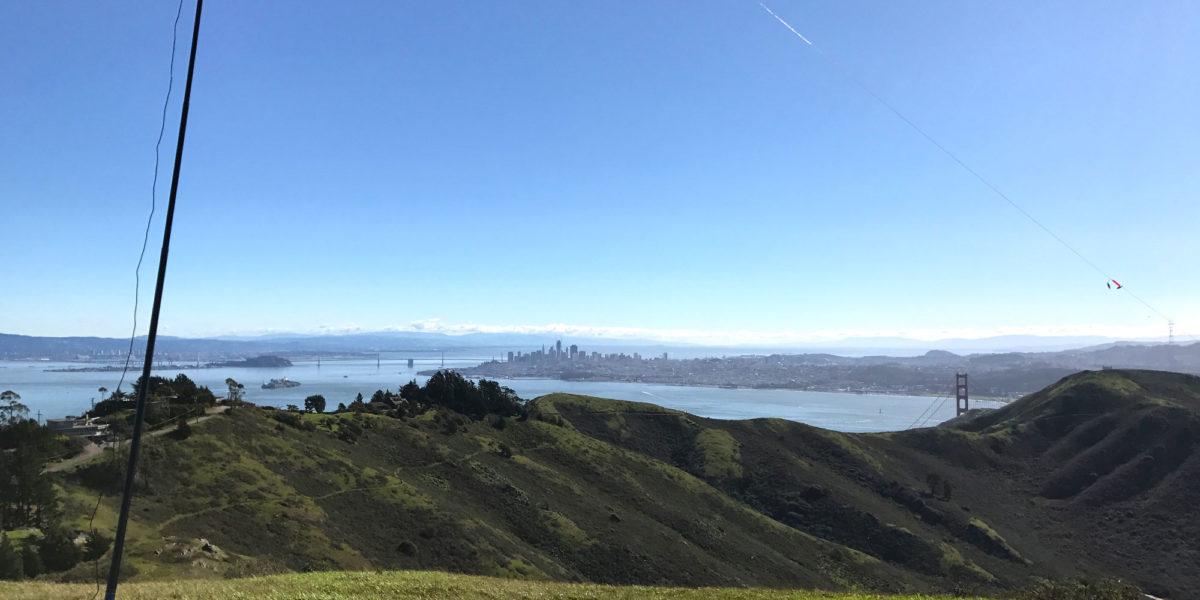
As you’ll see in this report, the featured photo is not from this trip. It’s from the first time I went – early last year. This year, I did this summit as a quick little activation prior to our SF Bay Area SOTA meet-up. Jeff, AA6XA (see his blog), had the idea of starting up a quarterly meet-up for Bay Area SOTA people. We change locations each time, since the Bay Area is pretty big, and we’d like to be able to activate different summits in the various areas. I wasn’t sure I’d be able to do a summit after the brunch, so I picked this one to do on the way to our meeting.
Getting There
For me, this involves a drive over the Golden Gate Bridge. I’ll almost never turn that down! Just navigate your way to the Spencer Ave Park & Ride and you should be able to find parking. Since I was there on an early Saturday morning, I was the only one in the lot.

Getting ready to head to the trail
The Hike
It’s a short one. But beautiful! It starts out with some stairs, taking you up into the trees.

The trailhead
Following the trail up the hill, you’ll be in a wonderland of green. I had the bonus of also being somewhat in the fog on this particular hike.

Nearing the top of the Morning Sun trail
After a little bit, you’ll reach the Alta trail. Turn left.

Nearing the top, turning left to head to the summit
This part of the hike is a very wide trail (road?). It’s also very wet. It wasn’t raining, per se, but the fog was causing the trees to create rain. Hiking quickly, I avoided lots of puddles and mud.

Heading south on Alta trail
At the end of Alta trail, you’ll go around a vehicle gate and turn right. Then you’ll head up the road that says “service vehicles only.”

Head up this road to get to the summit
Shortly, you’ll go around a chain meant to keep vehicles out. There’s clearly quite a bit of foot traffic around this part. When it isn’t foggy, the view from the top is pretty amazing, so I’m guessing it’s a pretty popular local destination. I don’t think there’s anywhere to park on the nearby street, but if there was, this would be nearly a drive-up summit.

Chain blocking vehicle access
The road becomes dirt and heads west as it gains elevation, before heading northeast towards the summit. Normally, the objective would be pretty clear as you approach, but in my case it was quite foggy.

Almost at the summit. Lots of towers at the top.
Just before you get to the fenced-in area at the top, there’s a use trail to the right. It’s not super-obvious, but it’s there. I tried taking a picture, but you can’t tell where it is in the picture. It’s one of those things where you have to be there. Taking the use trail around to the east side of the summit, there’s a nice place to set up in the grass.
Operation
Since there weren’t any antenna supports around (I don’t consider the fence a support, since that’d put me even closer to very high RF), I set up the QRPGuys Vertical. Having discovered my usual longer coax cable was faulty, I only had my shorter cable. So I set up the antenna right near where I’d want to sit. As soon as I got the pole vertical, it started accumulating water from the passing fog, and began to drip. Not really a problem, though I think I might put a coating on the circuit board for the antenna later on. I can imagine the moisture creating issues at some point.

KE6MT station set up on Richardson East Benchmark
The bands seemed pretty quiet on this activation. Even though it was early in the morning, I expected a bit more action. I ended up with 3 contacts on 40 meters and two contacts on 20 meters. There’s a chance my vertical antenna was picking up a bit more noise than usual, especially with the nearby towers in play. I think I did hear, too, that the bands weren’t in great shape that morning. Nonetheless, I made 5 CW contacts and packed it up after not too long—had to get to the SOTA meeting! Thanks to the chasers for getting your signal through one way or another!

My simple setup – using VK Port-a-log
Activation Log
| Time | Call | Band | Mode |
| 15:12z | W7RV | 7MHz | CW |
| 15:13z | WW7D | 7MHz | CW |
| 15:16z | NS7P | 7MHz | CW |
| 15:23z | W0MNA | 14MHz | CW |
| 15:24z | W0ERI | 14MHz | CW |